

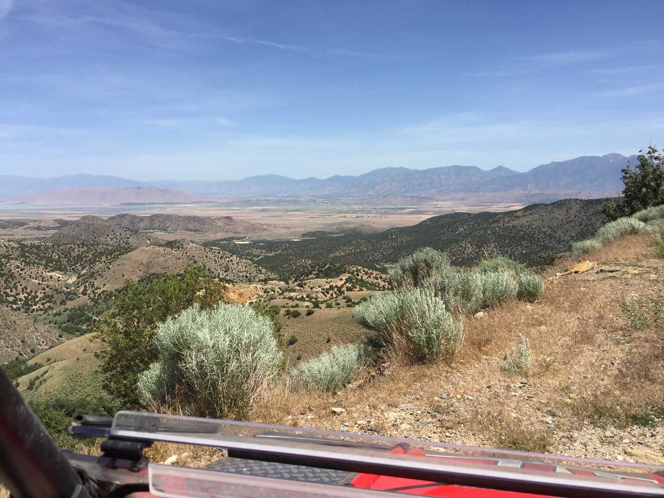
The Chief Tintic trail loops into the hills surrounding Eureka, Utah to explore the rich mining history in the area. The trails are gravel and graded county roads with a couple rocky sections on the North Loop. You can stage out of the town of Eureka which will have limited amenities at the convenience store.
There is a north and south loop for the trail with plenty to explore. Each loop took us about 2.5 hours at an average speed of 11 mph and covered 70 miles of riding. The area is littered with history of the once bustling mining town.
The area is littered with history of the once bustling mining town.
- Directions From the North
- Directions from the South
- Facilities: Limited, gas and convenience store in Eureka.
- OHVs: All sizes. No width limits. ATVs, MCs, UTVs, 4x4s on most trails. There are a few places where you might get some Rocky Mountain pinstriping from junipers reaching into the trail.
- Terrain: Easy – mostly graded county roads, gravels and a couple rocky sections on the north loop.
- Signage: The main routes have adequate signage but there is a fair amount of braiding of the trail through the juniper trees. Keep to the most established routes following GPS.
- KML File for Google Maps
- GPX File for your Garmin GPS or other Apps
We highly recommend you get GAIA GPS for your smartphone or tablet mobile device. GAIA GPS will allow you to download this trail complete with the photos you see here so you can be sure where you are at all times. Simply install the GAIA GPS app and save this trail from here: DOWNLOAD THIS TRAIL
Here is an embedded live link to GAIA GPS to allow you to explore the trail. Each of the blue markers indicates that a photo was taken at that location. To view the track and photos click here: GAIA GPS – Chief Tintic – Juab CO Utah
Would you like to see the Chief Tintic trail in an animated 3D flyover map? If it appears to pause that is likely a place we stopped for a while. It will continue, just wait a few moments. Link to 3D flyover.
Here is the 360 view at the trailhead. Feel free to tour around a bit inside Google Street Views. We have recorded the trail in 360, and it is now part of Google Street Views so you can take a virtual tour of the trail to see if it is for you. While we didn’t have time to ride all of the trail we think you will find this fairly representative of what you will find. We’ve made it a bit easier to navigate, scroll down and you will see more 360 embedded tours as we encounter intersections, trail markers or interesting places along the trail.
On any image, you can click the ‘X’ in the upper right corner and the view will change to an overview map showing the Google Street View blue lines. You can click anywhere on that blue line and drop down to the 360 ground-level views at that point.
You can move the image 360 degrees, click the arrow to move further down the trail and zoom in and out to take a closer look. Clicking the box in the upper right-hand corner will enlarge to full screen for a better view.
The Cheif Tintic Trail has a North and a South Loop. We started the day unloading at the Euereka City Park and driving across the highway to the South Loop trailhead behind the gas station just east of town.
This is the remnants of the Jesse Knight School. This area is the ghosttown of Knightsville “the only mining camp in the US without a saloon.”Jesse Knight is an interesting figure in the area. We highly suggest you search Jesse Knight Eureka.
What is left of the Humbug Mine. Another interesting piece of the areas history.
Continue on west. This was the site of the Sunbeam Mine.
Looking out over the Dragon Mine.
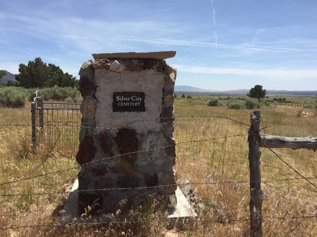
On the way back to Eureka you will come across the Silver City Cemetery.
Stay left here, you will pass a small concrete structure down the trail a ways. Follow the trail that runs parallel to town back to the park. From here you head back to the highway to find the north loop.
This is the trailhead for the north loop. You can access it at the east end of Eureka right off Highway 6. As you can see there is space for parking if you want to stage here.
Stay left here. The other spur deadends at a Juniper. You will notice there is a fair amount of braiding of the trail through the trees. Do your best to stay on the most established path. There is a gnarly spot coming down the hill with some larger rocks on the other side that will keep the ride interesting. Stay heading north on the trail.
Here is a photo gallery of all of the images we took along the way. Not necessarily in any order or sequence. Many are at trail intersections. You can see the photos and exactly where along the trail where taken: Click here for Photo Locations.


Emergencies
The closest medical help is the Central Valley Medical Center, 48 W 1500 N, Nephi, UT 84648 Phone: (435) 623-3000
Dial 9-1-1 for emergencies.
Juab County Sheriff: Dial 9-1-1 or (435) 623-1344 for non emergencies. 425 West Sheeplane Drive, Nephi, UT 84648
Utah Highway Patrol: Dial 9-1-1
We highly recommend you purchase a Utah Search and Rescue Assistant Card (USARA), learn more: https://secure.utah.gov/rescue/

