

Would you like to ride your ATV through the bottom of Bryce Canyon? Unfortunately, you can’t do that but you can ride the next best thing, the Casto Canyon Trail. Casto Canyon trail cuts through the same formation as Bryce Canyon National Park, the scenery is stunning and the trail is considered Easy for most riders young and old alike.
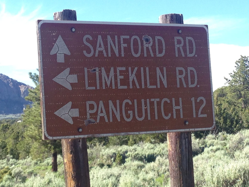
Casto Canyon is located due East of Panguitch Utah about 12 miles. Following Hwy 89 south from Panguitch turn east on Hwy 12 towards Bryce Canyon National Park for approximately 2 miles. Watch for a sign that says “Casto Canyon”, the turn will be to the north of Hwy 12 onto a well-maintained gravel road that most vehicles can travel nearly year-round. Follow this gravel road north for approximately 3 miles to the Casto Canyon Trail Head.
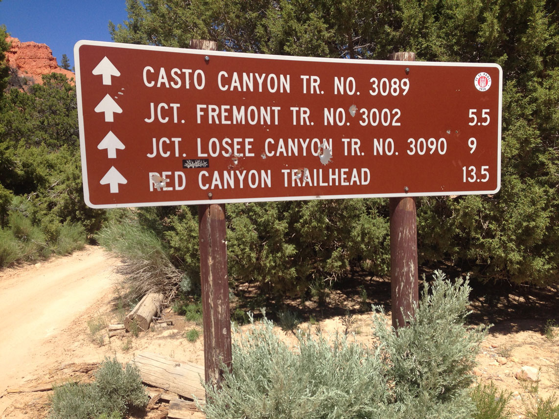
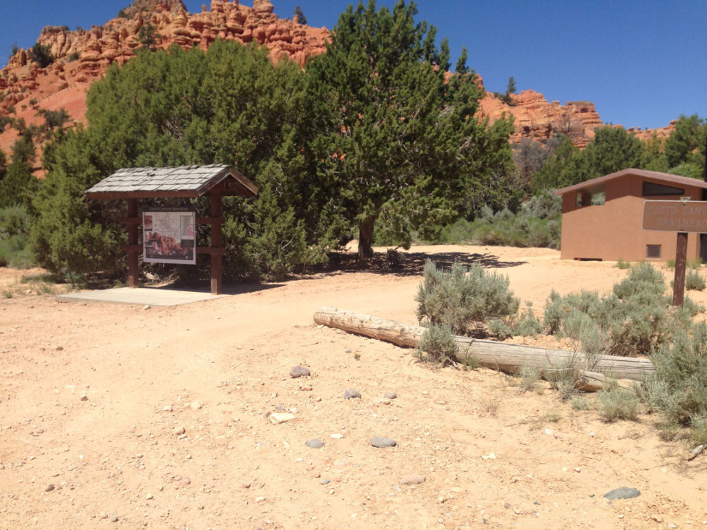
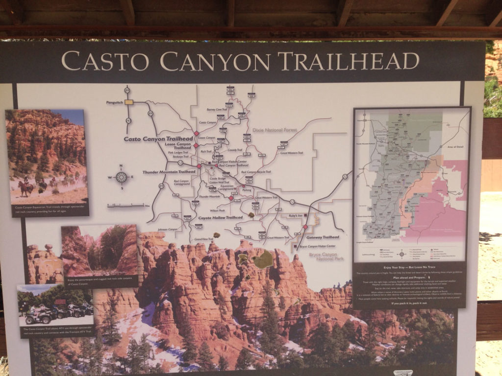
The Trailhead is well marked with Kiosks and mileage signs with a large parking lot with enough room to turn any vehicle/trailer combination.
A vault toilet is available at the trailhead but none are available after leaving the trailhead.
- There is no fee to park or ride.
- Directions from the South
- Directions from the North
- Facilities: Large Fenced Parking Lot, Vault Toilet at Trailhead
- OHVs: 50″ and under ATV’s, UTV’s, MC’s
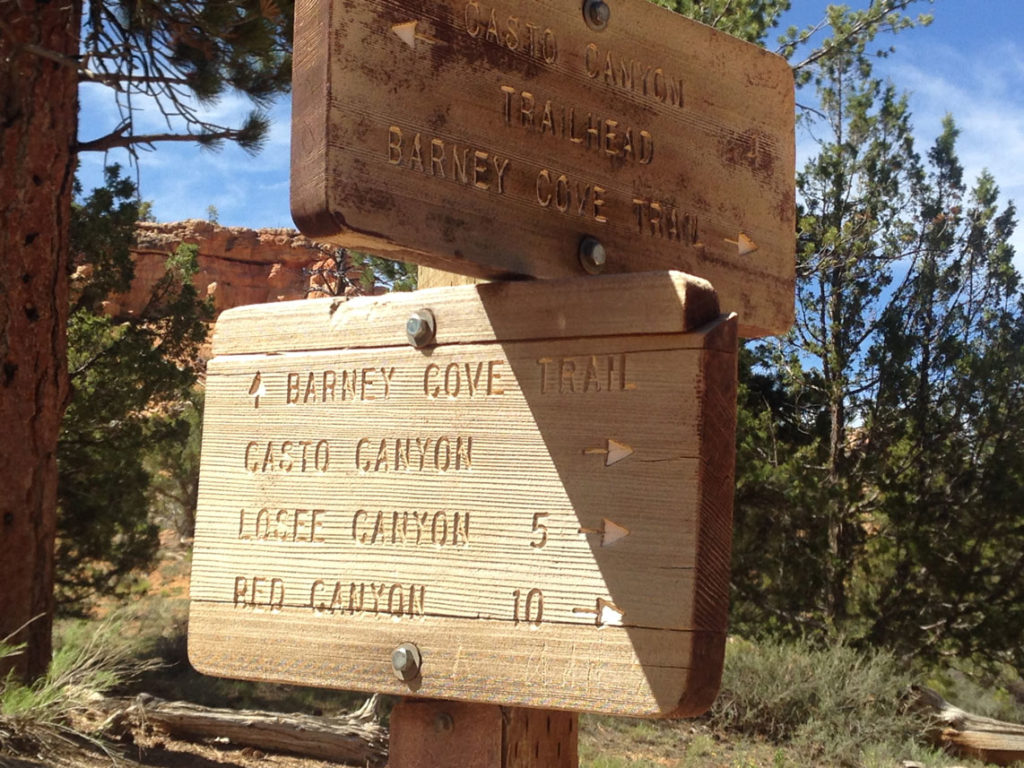
- Signing: Plenty of Signage and mileage updates at intersections.
- Map: Printable – Online Utah State Parks
- KML File for Google Maps
- GPX File for your GPS or other Apps
We highly recommend you get GAIA GPS for your smartphone or tablet mobile device. GAIA GPS will allow you to download this trail complete with the photos you see here so you can be sure where you are at all times. Simply install the GAIA GPS app and save this trail from here: DOWNLOAD THIS TRAIL
Here is an embedded live link to GAIA GPS to allow you to explore the trail. Each of the blue markers indicates that a photo was taken at that location. To view the track and photos click here: GAIA GPS – Casto Canyon
Would you like to see the Casto Canyon Trail in an animated 3D flyover map? If you notice a spot where the animation makes a beeline across the amp that is because I turned off the GPS for the return trip from Peterson Point.
Click Here: Ayvri 3D Animated Map

Here is the 360 view at the trailhead. Feel Free to tour around a bit inside Google Stree Views. We have recorded the trail in 360 and it is now part of Google Street Views so you can take a virtual tour of the trail to see if it is for you. While we didn’t have time to ride all of the trails we think you will find this fairly representative of what you will find. We’ve made it a bit easier to navigate, scroll down and you will see more 360 embedded tours as we encounter intersections, trail markers or interesting places along the trail.
On any image, you can click the ‘X’ in the upper right corner and the view will change to an overview map showing the Google Street View Blue lines. You can click anywhere on that blue line and drop down to the 360 ground-level views at that point.
You can move the image 360 degrees, click the arrow to move further down the trail and zoom in and out to take a closer look. Clicking the box in the upper right-hand corner will enlarge to full screen for a better view.
This is the 50″ barrier. PLEASE do not attempt this trail in any vehicle over 50″ wide.
Keep in mind that this trail follows the bottom of a canyon and may potentially have considerable flowing water at times that could be dangerous. If there is any water at all you should assume that the potential for a flash flood exists.
Soon enough the formations begin to resemble those in Bryce Canyon National Park.
Lots of large Pine and Juniper trees line the trail. Keep an eye on your whips and flags occasionally a limb hangs low enough to snag one.
At this point our OHV trail begins to technically follow “Barney Cove” and Casto Canyon diverges to the East as a hiking and equestrian trail only. PLEASE do not attempt to follow Casto Canyon beyond this point. You will see that it is clearly a single track path unfit for OHVs.
As you reach the top of the plateau you will pass another 50″ barrier gate. This one does not have the ‘bump’ you encountered down at the start of the trial. This might technically be the end of the Cato Canyon trail but we are not done yet. We want to go check out the Peterson Point Overlook that is not too far away.
Just after you pass the 50″ Barrier you will see a few signs. Follow the arrows to Peterson point 2 3/4 miles more for a fantastic view of Casto Canyon and the Panguitch valley.
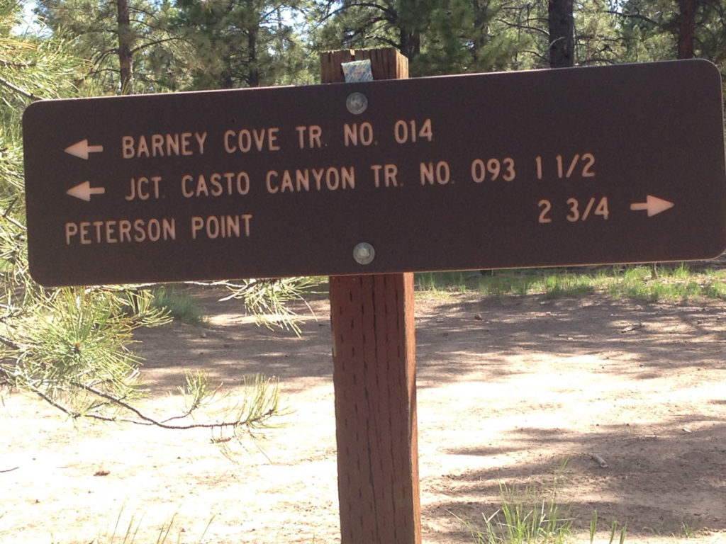
The view from Peterson Point is well worth the trip. Enlarge the image to full screen and see if you can spot Panguitch from here.
As you return to the upper 50″ barrier at the top of Casto Canyon you can choose to return to the start by retracing your route or following Limekiln Canyon. Limekiln is a much longer return route of around 17miles and details are of Limekiln are not included here.
Emergencies
The closest medical help is Garfield Memorial Hospital only a few due west in Panguitch. 200 N 400 E St, Panguitch, UT 84759 Dial 911 for Emergencies or (435) 676-8811.
Garfield County Sheriff Dial 911 or (435) 676-8811
BLM Office in Kanab Utah (435) 644-1300

