

The Orange trails are located in central Utah in Emery County and begin in the town Green River, 203 miles South East of Provo Utah. The Trailhead is located on the south side of I-70. Just west of the E. Main St. Exit off I-70 (the east side of town), turn West on New Area51 Rd 1,000 ft to the first intersection. You will see a very large parking lot on the south side of the intersection where you can park and turn even the largest rigs. If you are staying in Green River and simply want to ride out of town find 2270E, head south to Elgin Rd, turn right on Elgin to 800E. Follow 800E southward till it joins 900S and turn left. This will take you to the trailhead mentioned above. The Orange Trail explores a great expanse between Green River and the Moab area. Its features vary greatly and includes things like the Crystal Geyser. There are no services along the 70 miles of trail we rode, so stock up on anything you need before leaving Green River. This is a great place to get away and enjoy some solitude while exploring a seldom seen part of Utah. The riding is pleasant and scenic, trails vary from easy to intermediate (depending upon recent weather and erosion).
- Directions From the North
- Directions from the South
- Facilities: None, but you are in Green River.
- OHVs: All sizes. No width limits. ATV’s, MC’s, UTV’s, 4x4s on most trails.
- Signing: Most Trails have adequate signage
- Maps: Available in Price at the BLM Field Office. 125 South 600 West Price, UT 84501 Email: utprmail@blm.gov Phone: (435) 636-3600
- KML File for Google Maps
- GPX File for your Garmin GPS or other Apps
We highly recommend you get GAIA GPS for your smartphone or tablet mobile device. GAIA GPS will allow you to download this trail complete with the photos you see here so you can be sure where you are at all times. Simply install the GAIA GPS app and save this trail from here: DOWNLOAD THIS TRAIL
Here is an embedded live link to GAIA GPS to allow you to explore the trail. Each of the blue markers indicates that a photo was taken at that location. I To view the track and photos click here: GAIA GPS – Orange Trail
Would you like to see the Orange Trail in an animated 3D flyover map? If it appears to pause that is likely a place I stopped for a while. It will continue, just wait a few moments. 3D Flyover Link.
Here is the 360 view at the trailhead. Feel Free to tour around a bit inside Google Stree Views. We have recorded the trail in 360 and it is now part of Google Street Views so you can take a virtual tour of the trail to see if it is for you. While we didn’t have time to ride all of the trails we think you will find this fairly representative of what you will find. We’ve made it a bit easier to navigate, scroll down and you will see more 360 embedded tours as we encounter intersections, trail markers or interesting places along the trail.
On any image, you can click the ‘X’ in the upper right corner and the view will change to an overview map showing the Google Street View Blue lines. You can click anywhere on that blue line and drop down to the 360 ground-level views at that point.
You can move the image 360 degrees, click the arrow to move further down the trail and zoom in and out to take a closer look. Clicking the box in the upper right-hand corner will enlarge to full screen for a better view.
At this point, we chose to stay to the right as we begin our 70-mile loop. We’ll be back here much later in the day.
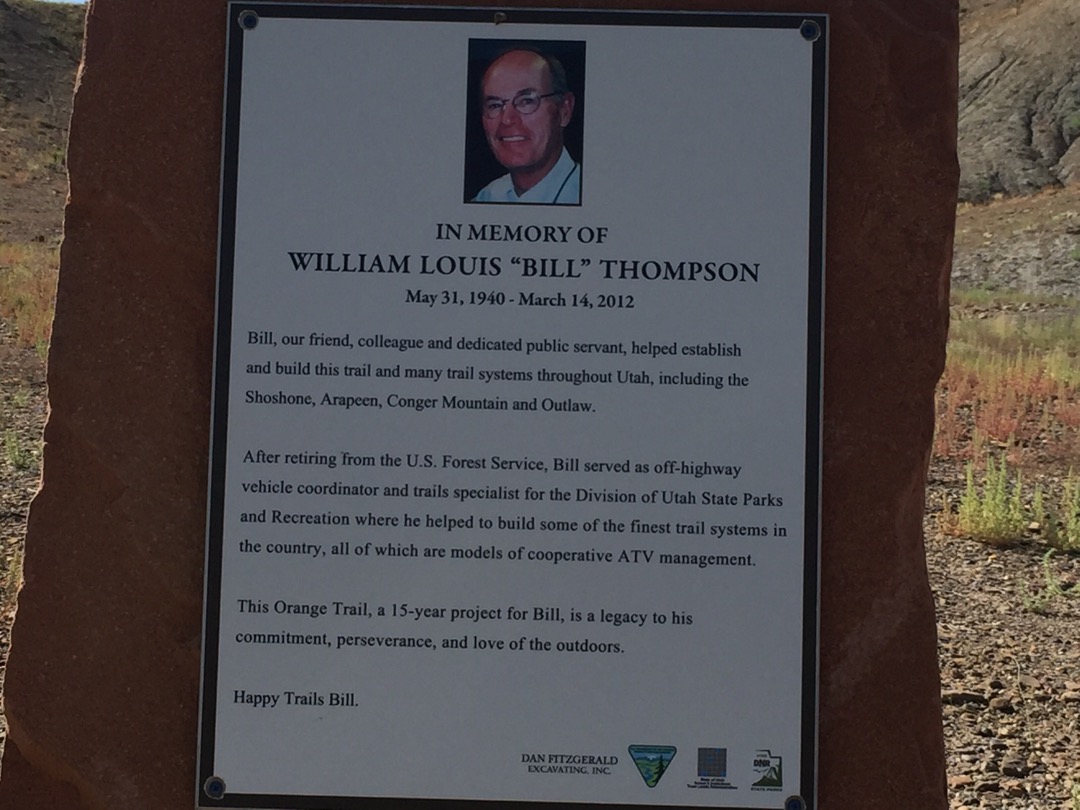
Though much of the trail has seldom seen a grader, it is in remarkably good shape and generally easy for most riders.A memorial to Bill Thompson (this trail was his project) sits at the intersection with the road to Crystal Geyser. Just spin the image around to see that road.
Frequent bottom of the wash sections
From this overlook, you can see the White Wash Sand Dunes
Out in the dunes, it is easy to lose the trail, GPS’s are great!
Certain areas are prone to flash floods like this wash. It hasn’t been long since there was a lot of water here.
Looking for a new place to hang your hat? I’d say this was hard living.
There are a few sections like this one that beginning riders might want to avoid. Bypasses are easily available by continuing on Salt Washington Rd N to Crystal Geyser Rd where it reconnects with this trail a few miles down the road.
If you were looking for the ‘Road Less Traveled’, this is it!
This left turn is easy to miss. See it over there in the rocks?
You will need to cross this pipeline, just take it easy as you go over it.
Here we are, right back where our big loop started.
Here is a photo gallery of all of the Images we took along the way. Not necessarily in any order or sequence. Many are at trail intersections. You can see the photos and exactly where along the trail where taken: Click here for Photo Locations.


Emergencies
The closest medical help is Green River Medical Center 585 Main St, Green River, UT 84525. Dial 911 for Emergencies or (435) 564-3434
If a Hospital is required Castle View Hospital is in Price. 300 North Hospital Dr Open 24 hours · (435) 637-4800
Emery County Sheriff Green River 911 or (435) 381-2404
Utah Highway Patrol Green River 911 or (435) 564-3474
BLM Office in Price (435) 636-3600

