

The Yellowstone trails are located in Duchesne County approximately 28.4 North of Duchesne UT, and 136 miles East of Provo Utah. It is a good idea to get detailed directions(below) before heading out as the route to the trailhead is a bit convoluted. Keep in mind that the road to the Trailhead passes through Reservation property and OHVs are not allowed on the road until you reach the forest boundary. The last few miles of the access road are quality gravel, the parking lot is quite large, and virtually any vehicle should have no trouble getting here. The Trailhead has good parking located on the Northside of Forest Rd 227. Approximately 64 miles of routes are marked within the area. It will take you a few hours or day(s) to explore this system depending on your driving and whether you want to hike into the incredible wilderness that is adjacent and it is well worth the trip. There are no services so stock up on anything you need before leaving Duchesne. There is a Forest Service Campground nearby if you intend to camp. This is a great place to get away and enjoy some solitude while exploring a seldom seen part of Utah. The riding is pleasant and scenic, trails vary from easy to intermediate to expert (depending upon recent weather and erosion).
- Directions From the North
- Directions from the South
- Facilities: Vault Toilet at the Trailhead
- You may encounter Gates, Leave them as you find them.
- OHVs: 50″ ATV’s, UTV’s & MC’s (several restricted entries)
- Signing: Most Trails have adequate signage
- Online Printable Map
- KML File for Google Maps
- GPX File for your Garmin GPS or other Apps
We highly recommend you get GAIA GPS for your smartphone or tablet mobile device. GAIA GPS will allow you to download this trail complete with the photos you see here so you can be sure where you are at all times. Simply install the GAIA GPS app and save this trail from here: DOWNLOAD THIS TRAIL
Here is an embedded live link to GAIA GPS to allow you to explore the trail. Each of the blue markers indicates that a photo was taken at that location. To view the track and photos click here: GAIA GPS – Yellowstone Trail
Would you like to see the Buckmaster Trail in an animated 3D flyover map? If it appears to pause that is likely a place I stopped for a while. It will continue, just wait a few moments. 3D Flyover Link.
Here is the 360 view at the trailhead. Feel Free to tour around a bit inside Google Stree Views. We have recorded the trail in 360 and it is now part of Google Street Views so you can take a virtual tour of the trail to see if it is for you. While we didn’t have time to ride all of the trails we think you will find this fairly representative of what you will find. We’ve made it a bit easier to navigate, scroll down and you will see more 360 embedded tours as we encounter intersections, trail markers or interesting places along the trail.
On any image, you can click the ‘X’ in the upper right corner and the view will change to an overview map showing the Google Street View Blue lines. You can click anywhere on that blue line and drop down to the 360 ground-level views at that point.
You can move the image 360 degrees, click the arrow to move further down the trail and zoom in and out to take a closer look. Clicking the box in the upper right-hand corner will enlarge to full screen for a better view.
There are two main sections of the Yellowstone Trails. We opted to ride the Northside this day so we turned left at this intersection just as we leave the Trailhead area. This will lead us up the mountain on the Northside of the valley. If you head straight across you will be headed to the Southside of the valley and the campgrounds. We’ll be back to do that later.
FR 227 is usually a well-groomed gravel road. We seemed to have perfect timing and clearly the road Graders had stopped working for the day so we enjoyed some atypically messy trail for a while. Don’t let this section of half graded road affect your opinion. I’m certain this is much better now.
We quickly climb up to the Center Park Trailhead. This is the dead-end of FR227. From here you can hike into the Wilderness. There is a Vault Toilet here.
Backtracking just a bit you will find Mill Park Elev 10,300 and miles of beautiful meadows ahead.
There are a few side trails marked 42″ wide only so we didn’t try them on our 50″ RZR.
See that trail sign on the right side of the Left-hand fork? It is on the wrong trail. It should be on the Right-hand fork trail. No worries, feel free to explore the Left Fork. The view at the end is great.
Here is the View I promised.
More beautiful mountain meadows.
Look like a great place for a lunch break.
A bypass so you don’t have to deal with the gate.
The remainder of this trail is going to be rocky, very rocky. Hopefully, someone will run a trail cat over it soon and clear the loose rocks that can get tiresome. Still an awesome trail.
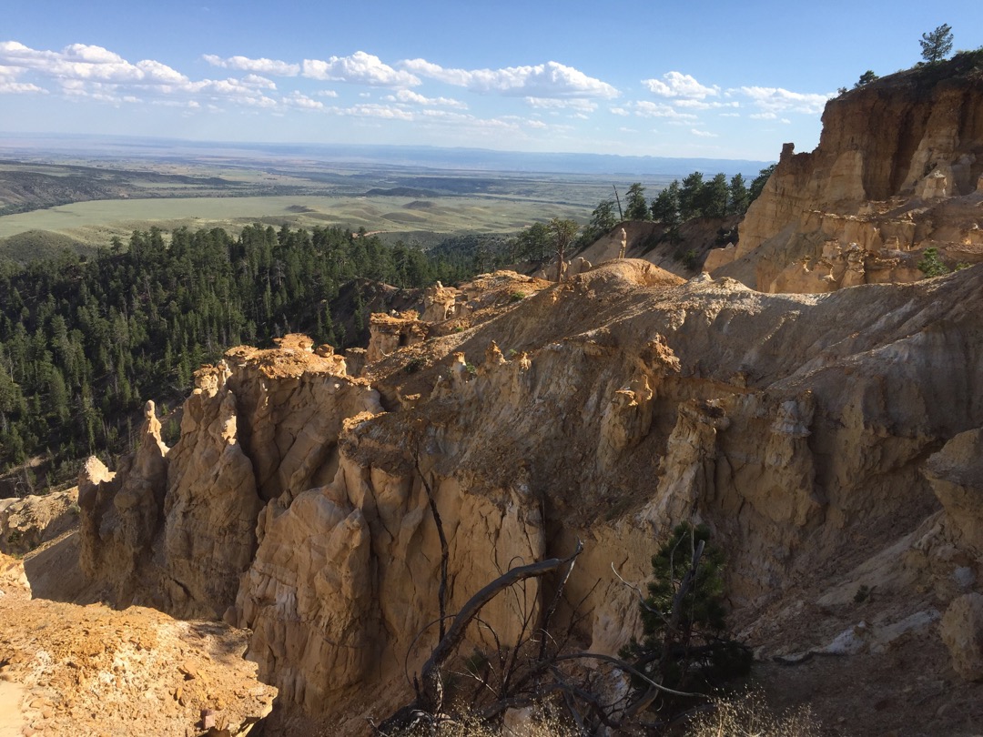
They call it Yellowstone because of this exposed formation, reminiscent of another similarly named place.
You only need to walk 50 feet to see this view, be careful of the edge.

Only a few more miles of this rocky road and you will be back at the Trailhead
Here is a photo gallery of all of the Images we took along the way. Not necessarily in any order or sequence. Many are at trail intersections. You can see the photos and exactly where along the trail where taken: Click here for Photo Locations.


Emergencies
The closest medical help is Duchesne Valley Medical Clinic 50 E 200 S, Duchesne, UT 84021 Dial 911 for Emergencies or (435) 738-2426
Duchesne County Sheriff 734 N Center St Dial 911 for Emergencies or (435) 738-1100
Utah Highway Patrol Dial 911
Ashley National Forest Duchesne/Roosevelt Ranger District 85 W Main St, Duchesne, UT 84021 (435) 738-2482

