

The Dowd trails are located in Dagget County approximately 49 miles North of Vernal UT, and 183 miles East of Salt Lake City Utah. The trailhead is located immediately off the FR094 exit from Hwy 44 very near milepost 14. Approximately 17 miles of routes are marked within the area. It will take you a few hours to explore this system depending on your driving and whether you take some of the hikes available. There are no services so stock up on anything you need before leaving Vernal, or Mountain View if coming from the North. There are a Vault Toilet and a picnic area at the Dowd Mountian Overlook area on the far East end of the trails. The view of Flaming Gorge is spectacular. The riding is pleasant and scenic, trails are generally easy for even beginners.
- Directions From the North
- Directions from the South
- Facilities: Vault Toilet at the Trailhead
- You may encounter Gates, Leave them as you find them.
- All OHVs: 50″ ATV’s, UTV’s & MC’s and full-sized 4x4s
- Signing: Most Trails have adequate signage
- KML File for Google Maps
- GPX File for your Garmin GPS or other Apps
We highly recommend you get GAIA GPS for your smartphone or tablet mobile device. GAIA GPS will allow you to download this trail complete with the photos you see here so you can be sure where you are at all times. Simply install the GAIA GPS app and save this trail from here: DOWNLOAD THIS TRAIL
Here is an embedded live link to GAIA GPS to allow you to explore the trail. Each of the blue markers indicates that a photo was taken at that location. To view the track and photos click here: GAIA GPS – Dowd Mountain
Would you like to see the Buckmaster Trail in an animated 3D flyover map? If it appears to pause that is likely a place I stopped for a while. It will continue, just wait a few moments. 3D Flyover Link.
Here is the 360 view at the trailhead. Feel Free to tour around a bit inside Google Stree Views. We have recorded the trail in 360 and it is now part of Google Street Views so you can take a virtual tour of the trail to see if it is for you. While we didn’t have time to ride all of the trails we think you will find this fairly representative of what you will find. We’ve made it a bit easier to navigate, scroll down and you will see more 360 embedded tours as we encounter intersections, trail markers or interesting places along the trail.
On any image, you can click the ‘X’ in the upper right corner and the view will change to an overview map showing the Google Street View Blue lines. You can click anywhere on that blue line and drop down to the 360 ground-level views at that point.
You can move the image 360 degrees, click the arrow to move further down the trail, and zoom in and out to take a closer look. Clicking the box in the upper right-hand corner will enlarge to full screen for a better view.
The trailhead parking is large enough for almost any rig. There are plenty of dispersed camping spots available on Dowd Mountain if you would like a pleasant place to pitch camp for the night.
You can go left or right at this 4-way intersection. Either way, you come out at the same spot, another 4-way intersection a few miles down the center road near Dowd Mountian Overlook area. We chose to take FR614 to the right.
Occasionally the trees open up onto vast mountain meadows
If you would like to take the hike down Carter Creek Trail you would want to hang right here. It is a dead-end at the trailhead not too far away.
Here we are at the 4-way intersection we mentioned earlier. A right turn will take us to the Dowd Mountain Overlook
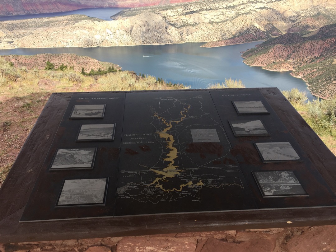
Here at the Dowd Mountian Overlook you will find a Kiosk explaining what you see in the distance, a Vault toilet, and picnic tables. There are a few short trails leading to slightly better views of Flaming Gorger Reservoir.
There are several roads that take off from the main trails like this one that offers some very nice dispersed camping that most vehicles can access. All of these roads are dead ends.
You will be sharing the trail with mountain bikers and will find a few single tracks crossing your path like the one to the right here. Please respect the trails and keep to the one that obviously fits your vehicle.
Here is a photo gallery of all of the Images we took along the way. Not necessarily in any order or sequence. Many are at trail intersections. You can see the photos and exactly where along the trail where taken: Click here for Photo Locations.


Emergencies
The closest medical help is Ashley Regional Medical Cente 150 W 100 N, Vernal, UT 84078 Dial 911 for Emergencies or (435) 789-3342
Dagget County Sheriffs Office Manila UT Dial 911 for Emergencies or (435) 784-3255
Utah Highway Patrol Dial 911
Ashley National Forest 355 North Vernal Avenue Vernal, UT 8407 435-789-1181

