

The Collet Top Loop is an intermediate ride south of the town of Escalante in the Grand Staircase-Escalante National Monument. This is an all day ride that takes you almost 73 miles in about six hours of drive time.
The trail follows a few different BLM Routes including BLM 200, 230 and 300. These routes take you through areas of Cedar Wash, Hole-in-the-Rock Road and Collet Top.
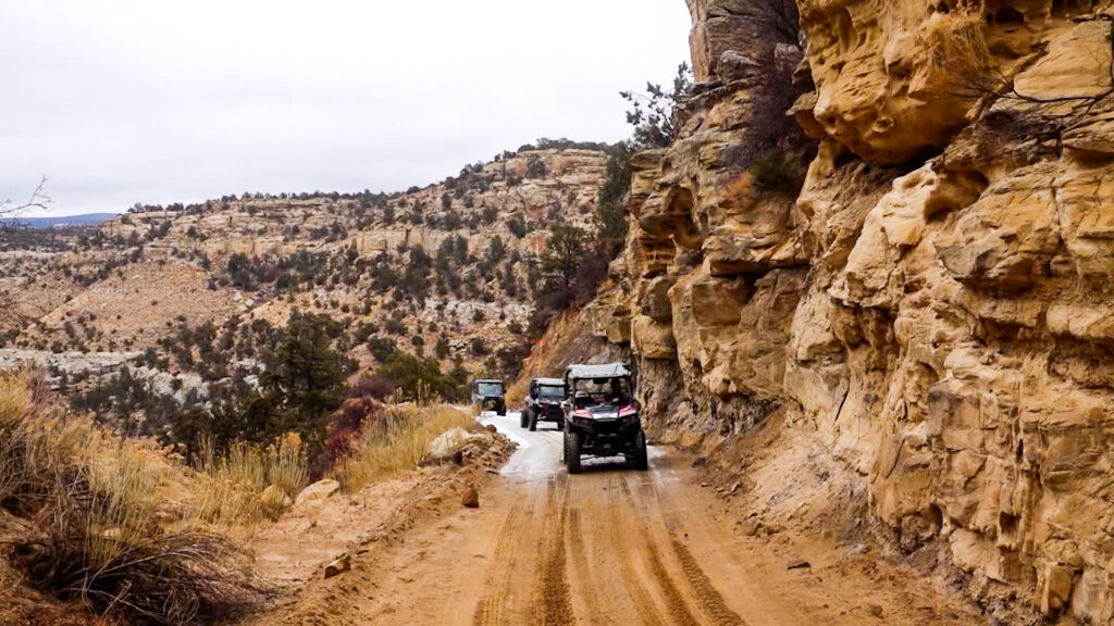
The ride features mostly maintained dirt roads, but the road can get a little rough while traveling through the washes located at the bottoms of canyons.
Throughout the ride you’re greeted by amazing geological structures the monument is known for, as well as some archaelogical sites as well. There are opportunities for short hikes through the trail that treat you to points of interest, including the Cedar Wash Arch, and Twenty Mile Dinosaur Tracks.
There is plenty of lodging in and just outside of the town of Escalante. The town has every necessity between grocers and gas stations. There is also opportunity for primitive camping along Hole-in-the-Rock Road.
Prepare adequately for each season. The area is very hot and dry during the summer, so extra water is highly recommended. During the winter the washes can get wet or even frozen over. Drive cautiously through these areas. Flash flooding is also a possibility. Keep an eye on the weather.
Overall the Collet Top Loop offers something for everyone and would be fun an experienced driver to bring their whole family.
- Directions From the North
- Directions from the South
- Facilities: Lodging, restaurants, fuel and groceries are all available in Escalante, Utah. Staging can be done from the town of Escalante. The trail stretches to very remote areas so don't count on facilities once you depart.
- OHVs: All sizes. No width limits. ATVs, MCs, UTVs, 4x4s on most trails.
- Terrain:Dirt and gravel roads, desert washes that are dry in the summer, wet in spring, and frozen over in winter.
- Signage: Signage for main roads and distances. Minimal signage for points of interest.
- KML File for Google Maps
- GPX File for your Garmin GPS or other Apps
- Emergencies: The closest medical help is Kazan Memorial Clinic in Escalante - 570 East Moqui Lane, Escalante, UT 84726 Open 9AM-5PM Closed Saturday and Sunday. Closest hospital is the Garfield Memorial Hospital in Panguitch - 200 N 400 E St, Panguitch, UT 84759 Emergency room open 24 hours a day.
- Garfield County Sheriff: Dial 9-1-1 for emergencies or Non-Emergency Dispatch: 435-676-2678. Utah Highway Patrol: Dial 9-1-1. We highly recommend you purchase a Utah Search and Rescue Assistant Card (USARA) learn more: https://secure.utah.gov/rescue/
GAIA
We highly recommend you get GAIA GPS for your mobile device. GAIA GPS will allow you to download this trail complete with the photos you see here so you can be sure where you are at all times. Simply install the GAIA GPS app and save this trail from the button below.
Here is the 360 view at the trailhead. Feel free to tour around a bit inside Google Street Views. We have recorded the trail in 360 and it is now part of Google Street Views so you can take a virtual tour of the trail to see if it is for you. We’ve made it a bit easier to navigate, scroll down and you will see more 360 embedded tours as we encounter intersections, trail markers or interesting places along the trail.
On any image, you can click the ‘X’ in the upper right corner and the view will change to an overview map showing the Google Street View blue lines. You can click anywhere on that blue line and drop down to the 360 ground-level views at that point.
You can move the image 360 degrees, click the arrow to move further down the trail and zoom in and out to take a closer look. Clicking the box in the upper right-hand corner will enlarge to full screen for a better view.

