


The Charlie trails are located in Uintah County approximately 14 miles North West of Vernal UT in Dry Fork Canyon, and 220 miles East of Salt Lake City Utah. The trailhead (such as it is) is located at 40.5647694,-109.6879361 Just 2,000 Feet north of the Red Cloud Loop and Dry Fork Settlement Rd Intersection. There is limited parking at the intersection (Don’t block the gates). While the Road you will take is called West Red Cloud Loop Rd there are no signs to that effect and the road might even appear to be private as the beginning is poorly maintained. While we rode approximately 27 miles there are many many more miles or trail in the area. It will take you a 3-4 hours to explore this system depending on your driving and whether you take some of the side trails available. There are no services so stock up on anything you need before leaving Vernal.
- Directions From the North
- Directions from the South
- Facilities: None
- You may encounter Gates, Leave them as you find them.
- All OHVs: 50″ ATV’s, UTV’s & MC’s and full-sized 4x4s
- Signing: Most Trails have adequate signage
- KML File for Google Maps
- GPX File for your Garmin GPS or other Apps
We highly recommend you get GAIA GPS for your smartphone or tablet mobile device. GAIA GPS will allow you to download this trail complete with the photos you see here so you can be sure where you are at all times. Simply install the GAIA GPS app and save this trail from here: DOWNLOAD THIS TRAIL
Here is an embedded live link to GAIA GPS to allow you to explore the trail. Each of the blue markers indicates that a photo was taken at that location. To view the track and photos click here: GAIA GPS – Charley Park
Would you like to see the Buckmaster Trail in an animated 3D flyover map? If it appears to pause that is likely a place I stopped for a while. It will continue, just wait a few moments. 3D Flyover Link.
Here is the sign at the intersection where you can park a truck and trailer. Anything larger and you may need to make arrangements elsewhere or enter the trail from further up Red Cloud Loop.
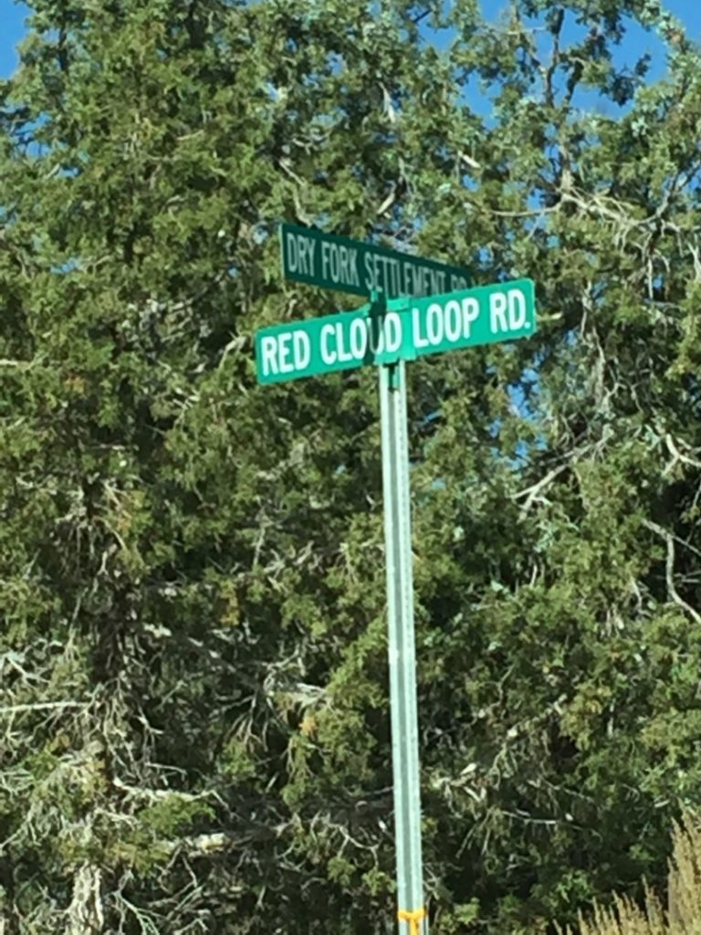
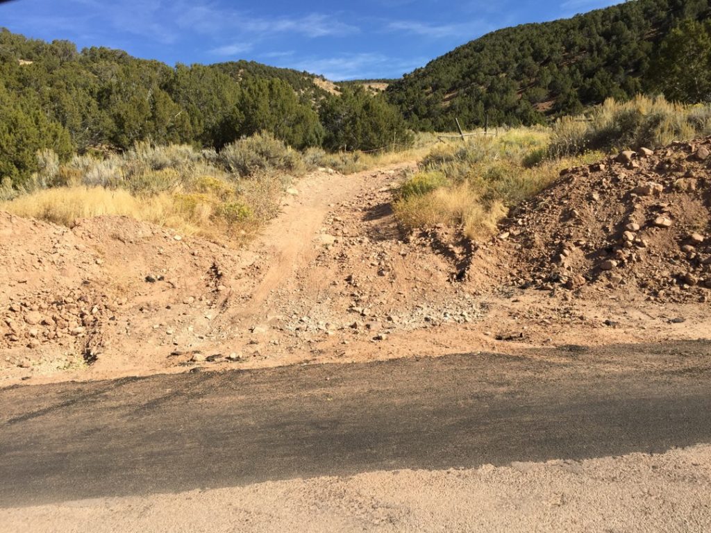
The Trailhead such as it is is an unmarked road leaving the pavement. The name is Red Cloud Loop West but there is no sign. There is no parking here and no facilities.
Feel Free to tour around a bit inside Google Stree Views. We have recorded the trail in 360 and it is now part of Google Street Views so you can take a virtual tour of the trail to see if it is for you. While we didn’t have time to ride all of the trails we think you will find this fairly representative of what you will find. We’ve made it a bit easier to navigate, scroll down and you will see more 360 embedded tours as we encounter intersections, trail markers or interesting places along the trail.
On any image, you can click the ‘X’ in the upper right corner and the view will change to an overview map showing the Google Street View Blue lines. You can click anywhere on that blue line and drop down to the 360 ground-level views at that point.
You can move the image 360 degrees, click the arrow to move further down the trail, and zoom in and out to take a closer look. Clicking the box in the upper right-hand corner will enlarge to full screen for a better view.
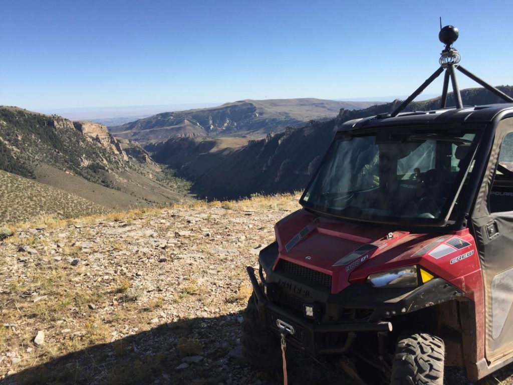
Due to a recent fire, the view up on top is unrestricted.
After an initial rough section of trail, we have smooth sailing most of the rest of the trails in Charley Park.
While you may not encounter many other riders here, you will find plenty of cows all over the mountain. Please don’t harass them and slow down to a crawl when passing.
There are plenty of dead-end trails in Charley Park but with a view like this in the end, they are worth the trip.
This is typical of much of the trail up on top. Mixed conifers and Apsens.
You may encounter logging equipment and a bunch of dead-end side roads. If they look like this one they are most certainly logging access roads that simply end a few hundred yards away from the main roads.
The Forest Service recently filled this muddy intersection with gravel. We are going to hang a Left here and head west into the other sections of Charley Park.
Charley Park is famous for it’s enormous mountain meadows. Keep an eye out for cows and deer. We will keep left to head to the south end.
Remember those cows I mentioned? If you encounter a large herd in the road just slow to a crawl and they will step out of your way. Please don’t scare or harass them. They belong to this guy and he knows everything about this mountain. Stop and say hi. The dogs were friendly but we could tell they wanted to get to work.
This is Charley Park Spring inside that rail fenced circle.
We found the end, such as it is. I guess not every dead-end has a spectacular view.
This dead-end has a better view.
While this was the end of our ride there is plenty more to explore in Charley Park. We’ll be back. the road straight ahead took us right back to the trailhead.
Here is a photo gallery of all of the Images we took along the way. Not necessarily in any order or sequence. Many are at trail intersections. You can see the photos and exactly where along the trail where taken: Click here for Photo Locations.


Emergencies
The closest medical help is Ashley Regional Medical Cente 150 W 100 N, Vernal, UT 84078 Dial 911 for Emergencies or (435) 789-3342
Uintah County Sheriff’s Office 641 E 300 S, Vernal, UT 84078 Dial 911 for Emergencies or (435) 789-2511
Utah Highway Patrol Dial 911 641 East, 300 South, Suite 300
Vernal, Utah 84078 (435) 781-6740
Ashley National Forest 355 North Vernal Avenue Vernal, UT 8407 435-789-1181

